Screen Education Edinburgh was originally known as Pilton Video, which was founded in 1981 to develop people, support the work of local organisations, and be at the heart of community development exclusively in North Edinburgh, through film education and production. In 1995 the organisation grew to become an Edinburgh-wide resource, before rebranding to Screen Education Edinburgh in 2011.

Geddes as Town-Planner

It is perhaps safe to say that the modern practice of town-planning in this country would have been a much simpler thing if it had not been for Geddes. There was a time when it seemed only necessary to shake up into a bottle the German town-extension plan, the Parisian Boulevard and Vista, and the English Garden Village, to produce a mechanical mixture which might be applied indiscriminately and beneficiently to every town in this country; thus would it be "town-planned" according to the most up-to-date notions. Pleasing dream! First shattered by Geddes, emerging from his Outlook Tower in the frozen north, to produce that nightmare of complexity, the Edinburgh Room at the great Town-Planning Exhibition of 1910.

It was a torture-chamber to those simple souls that had been ravished by the glorious perspectives or heartened by the healthy villages shown in those other ampler galleries. Within this den sat Geddes, a most unsettling person, talking, talking, talking ... about anything and everything. The visitors could criticize his show-the merest hotch-potch-picture postcards-newspaper cuttings-crude old wood-cuts --strange diagrams-archaeological reconstructions: these things, they said, were unworthy of the Royal Academy-many of them not even framed-shocking want of respect; but if they chanced within the range of Geddes' talk, henceforth nothing could medicine them to that sweet sleep which yesterday they owed. There was something more in TownPlanning than met the eye!

This was Geddes' first town-planning emergence into public; but he had long been subterraneously at work, and his disciples were scattered over the face of the land gradually spreading his doctrine, until now all the leaders of the movement base their practise on his theory.

Bluntly, what Geddes taught was, that if you wish to shape the growth of a town, you must study it: it sounds simple, but the Civic Survey, by whose agency it can be done, is a sinister and complicated business. And, indeed, a Civic Survey is not sufficient: it is necessary to go outside the town and survey its region - to grasp in a word its relation to the country and further to the world at large! It may with safety be said that the errors of our national Reconstruction can be attributed to the neglect of this teaching of Geddes. For while the town-planners of this country are converts, the politicians are not, though the regional devolution of Housing shows some faint appreciation.

But Geddes is no centripetalist, concentrating on the individual town to be dealt with. His subsequent exhibitions take the whole world within their scope; but always the intensive study of the particular city prevents the application of facile generalization, that fatal danger to town-planning.

Geddes' influence will never be known to the world at large - he works by his disciples-his teaching is of such sort that it does not get watered down In transmission: it is a sort of vital idea-a divine inoculation that goes on spreading its infusion without exhausting its original élan.

And the hard-headed business man is beginning to recognize that the Geddesian method is the only safe one. Sheffield, the hardest-headed town in this country, has found schemes under the Town-planning Act (the politicians' solution) not enough: they begin just about where you should be ending; you can't plan for the future growth without improving the centre; you should not build houses without studying where the people want to work; you can't understand what the future of Sheffield will be, unless you know something about her past; in a word, you need a Civic Survey.

So Geddes the prophet, the magician of the enchanted Edinburgh Tower, is being recognized as the practical man, the one who shows how to build town-planning on a sure foundation – social, geographical, historical, industrial. It was fitting that Sheffield, the most coldly scientific of our technical cities and the one whose historic legacies and difficult site make town-planning obviously an involved problem, should be the first to adopt publicly the Geddes method. The work of the War Civic Surveys carried out in London, Leeds, Manchester and elsewhere, under H. V. Lanchester's direction, will bear similar manifest fruit elsewhere.

But the full extent of the debt which England, Scotland, Ireland, India and Palestine owe to Geddes will never be adequately realized.

From a letter by Professor Patrick Abercrombie, Department of Civic Design, University of Liverpool;
Editor of "Town-Planning Review;" Town-Planner for Sheffield and Dublin
Defries, A., (1927), The interpreter Geddes: The man and his gospel, pp.322-325

Town and Country Planning (Scotland) Act 1947

Online at: legislation.gov.uk


Aims of Civic Survey and Plan

PURPOSE
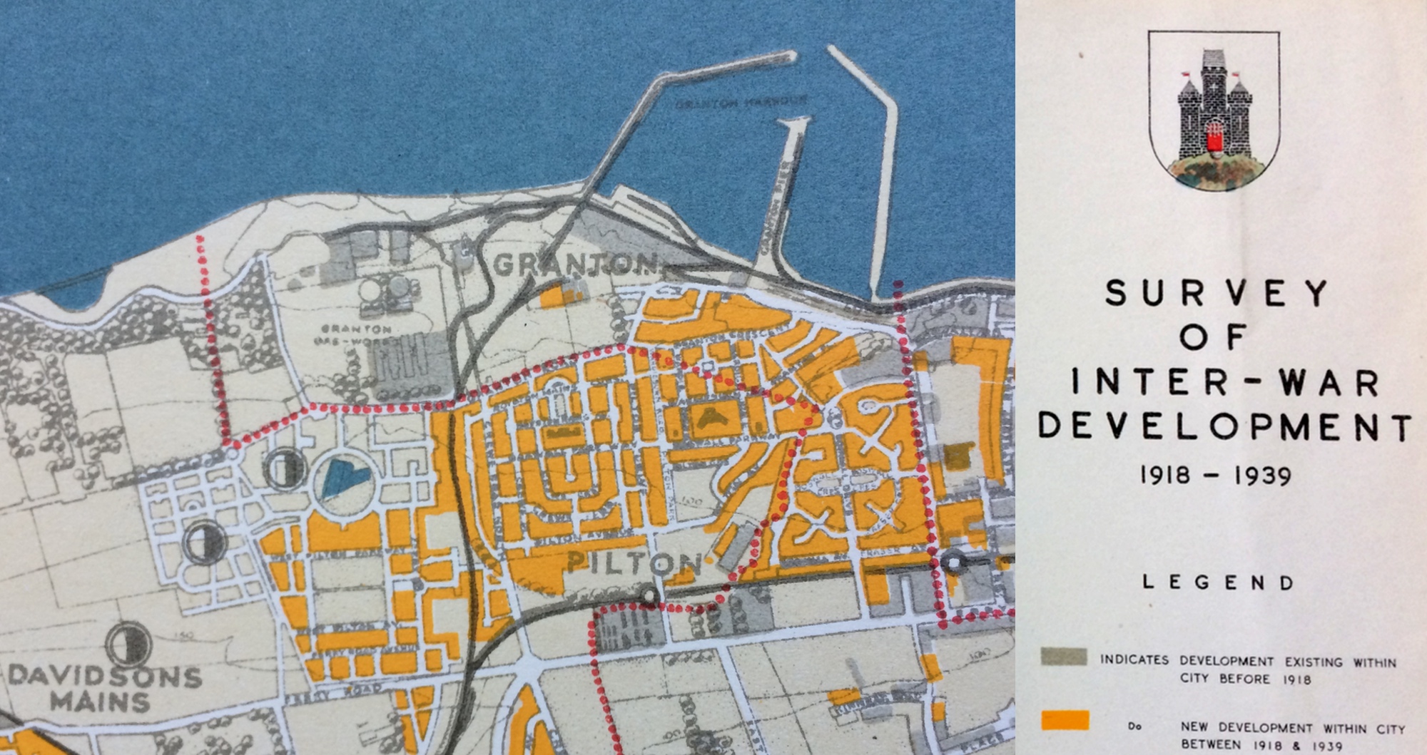
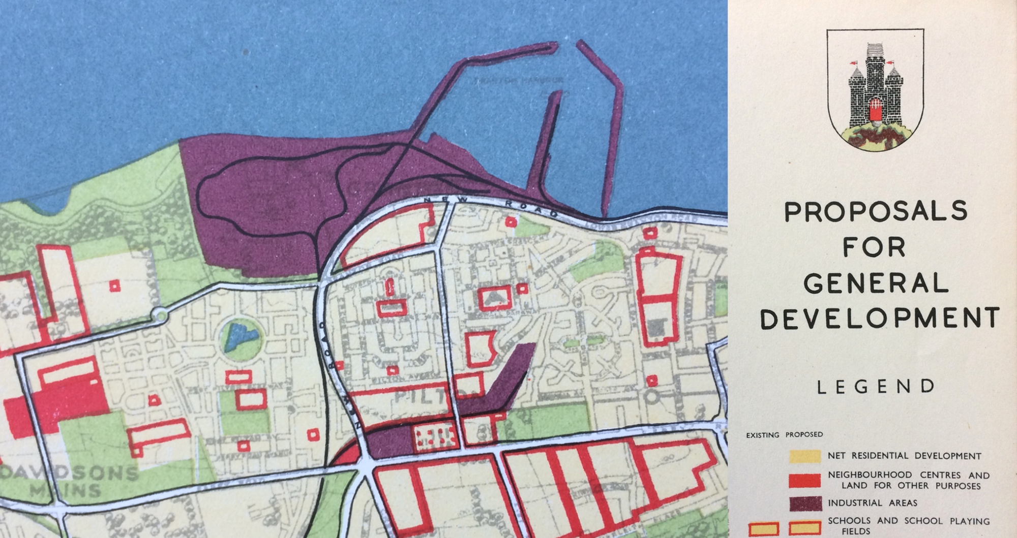
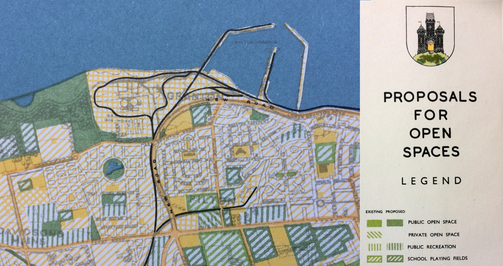
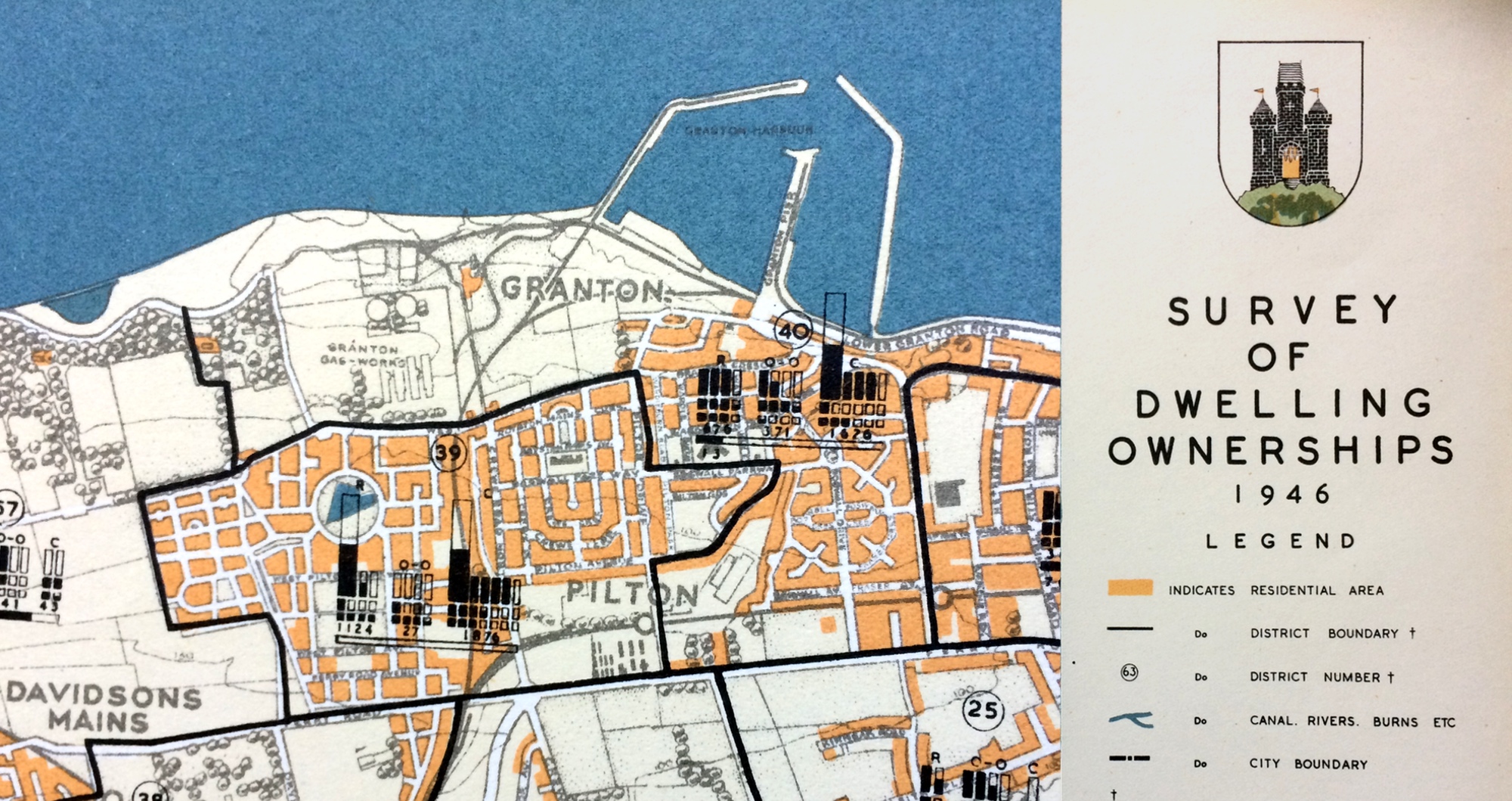
A survey is required to provide up-to-date information about the problems in the city: to anticipate development which will seek to establish solutions whether or not there is a plan. It is better to guide future development by means of a development plan showing all that can be anticipated than hope for the best by leaving it to follow an unguided course.

TRENDS
Importance is attached to the past trends of human activities whether they are economic, as in the industrial field, or whether they are social, as may be reflected in the community life of the home and its environment. In some measure we have to be prophets in planning for the immediate and more remote future, so that it is necessary to consider past trends with those of the present - the present being more indicative of the immediate future, while past trends considered together with those of the present, can give a lead for the more remote future.

COMPLETE PICTURE
From the mass of data obtained, and illustrated in the form of maps the Planning Scheme may emerge as a logical sequel marrying what is best from the old, with what is considered best for the future. The chapters describe the facts that may be read from these maps; and a special effort has been made to present the information in a way that is at once attractive and easy in the visual sense to comprehend. This should, therefore, encourage their study and eliminate that natural aversion to the dry-as-dust statistical table.

HISTORICAL BACKGROUND
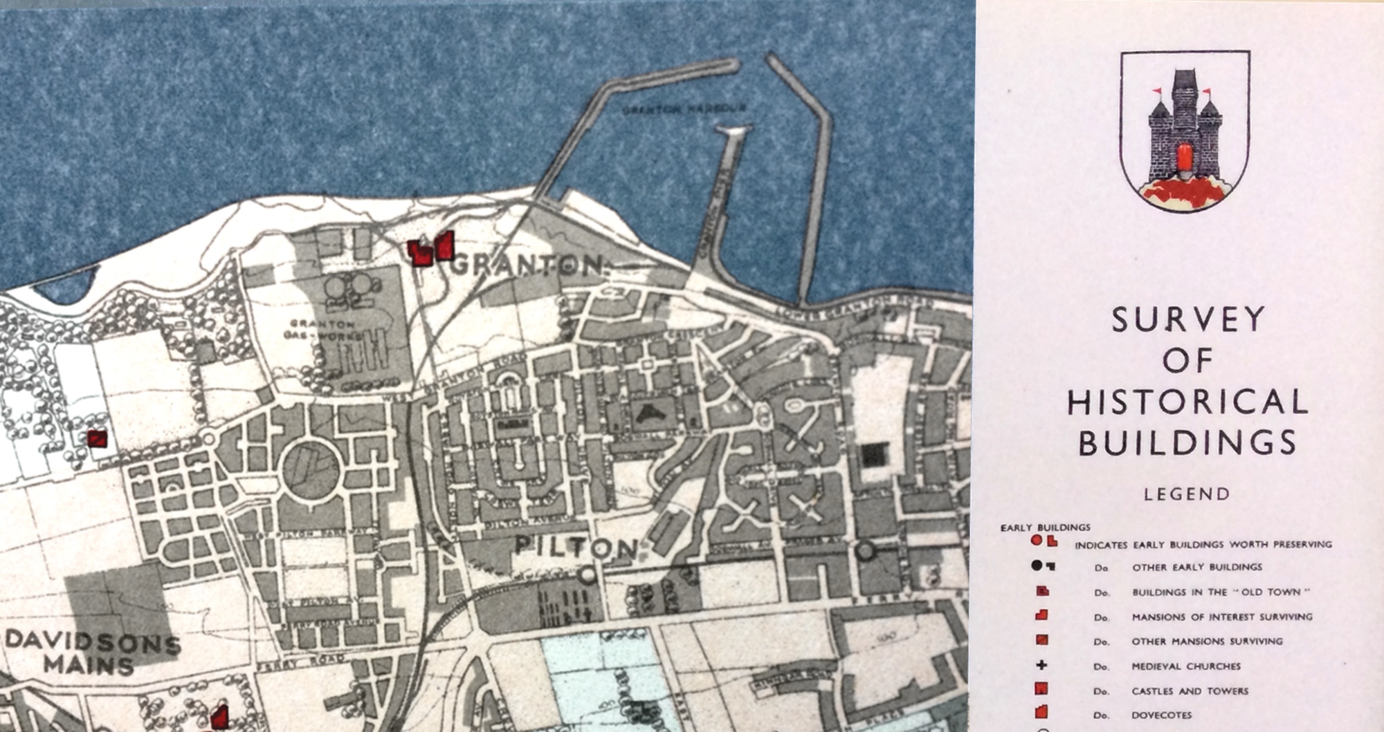
Historical buildings and features of the city offer a fine heritage. They reflect the traditional character of the periods in the city's historical development. The best and most interesting have been surveyed and recorded so that development proposals may avid, if possible, demolition. Where a conflict of interest between the historical and future development arises the relative values of each may be justly weighed in the balance.

A Civic Survey and Plan for the City and Royal Burgh of Edinburgh, Prepared for the Town Council, 1949
Patrick Abercombie and Derek Plumstead

The Civic Survey of Edinburgh
Prof. P Geddes, Outlook Tower
University Hall
Edinburgh

The survey of our city and its region is of fundamental importance alike in the understanding of their past and present, and towards the preparation of the Greater Edinburgh of the near future

Such a survey has long been in progress, and with stimulus to its workers in Edinburgh, and to wider initiatives beyond, e.g. as nucleus of the long itinerant Cities and Town Planning Exhibition, the Regional Association, etc. Beyond the interpretation of the conditions of the city of the present we seek to connect our studies of contemporary conditions with their origins—local regional, and general.

This inquiry requires, first, a survey of our geographical environment in its fullest and deepest aspects; secondly, a survey also of the history of the city and region, and of Scotland in particular; with general history so far as bearing on this, and necessarily, therefore, from the earliest beginnings of civilisation. We are thus learning to view history not as mere archælogy not as more annals, but as the study of social filiation. That is, the determination of the present by the past;

Such a detailed and comprehensive survey of a city is necessarily difficult and laborious, though not insuperably so; and it is therefore not surprising that there are students and workers in education and in the housing and town-planning movements who hesitate to undertake or oven encourage such surveys, lest good and urgent work be delayed. Let us here waive this controversy; and with the series of maps before us ran over some of the main phases of the development of Edinburgh.

Edinburgh Survey Exhibit : General Map ; also Photographic Panorama, and large Frieze, in oil, by Eric Robertson, of 'Old Edinburgh from Outlook Tower', showing complex modern development to be surveyed, i.e., analysed and interpreted geographically, historically, socially, etc.

We seek thus to interpret our observation of the present, and even to discern something of the opening future: for that is already incipient, as next season's buds are already here.

The modern Edinburgh and Leith extend far around these in all directions..and which is thus in need of fuller consideration, economic, hygienic, and civic, than it has yet received.

A hillfort associated at once with a seaport and with an agricultural plain...and such a threefold co-operation is conducive alike to agricultural efficiency, to maritime enterprise and commerce, and to regional as well as civic culture.

For the soil of the past teems with its dormant seeds, each ready to leap into life anew, be this as weed or flower.

Thus our city survey continually brings out the strange alternation and interaction of good and evil, evil and good.

And the strange yet constant alternations of our Edinburgh architecture – here of picturesqueness, there of utilitarian plainness - thus appear as the natural and necessary expressions in architecture of these contrasted social types.

Here, then, we have a period of town planning and of architectural execution surpassing even the lesson of London ; yet breaking down, also, in its turn.

Our photographs and maps are arranged so as to show this progress of design and construction, yet also to bring out the reason of their arrest and breakdown, with abandonment of their unused spaces to the contemporary squalor or confusion.

Gentle but decided criticism to bear upon much of the town planning of our time, which, with all its specialising upon communication here or comfortable dwellings there.

Retrospect, rightly interpreted, not only illuminates the present, but sweeps though this, and forward again into intelligent foresight.

Our city surveys, in fact, descend throughout their veritable inferno, yet ascend towards corresponding circles of higher life. What are the circles of ascent or of decline? The needful stereoscopic thought - the analyses of a strangely mingled and ever-changing ebb and flow, the rise and fall of historic and industrial evolution."

Transactions of the Town Planning Conference
October 2010, pp.537-574

Sir Terry Farrell
Edinburgh Council Report
September 2009
Online at:
Edinburgh City Council

Housing and Maisonettes at Edinburgh
THE ARCHITECT and Building News,
9 May 1957

Disuse and dereliction
Granton Waterfront is the name given to the land between West Granton Road and the Firth of Forth, east of Marine Drive and up to and including Granton Harbour. It was an area of gas works, petrol storage and industrial and storage uses, which by the late 1990s was falling into disuse and dereliction. At that point the Council began to acquire land within the area and began the process of comprehensive, planned redevelopment.
forthestuaryforum

Llewelyn-Davies wins £500m Edinburgh waterfront
Powerbrokers behind the £500 million redevelopment of Edinburgh waterfront have confirmed Llewelyn-Davies as masterplanner of the next stage of the 63ha mixed-use scheme, after initial work for the site by edaw and czwg (AJ 24.6.99). Scotland's biggest regeneration project will see the architect masterplan an eight-mile strip of derelict land in Granton beside the Firth of Forth. The 15-year project will include shops, offices and housing for 7000 people. There will be around 3700 owned and rented homes and the architect is considering planting a forest of 380,000 trees. Llewelyn-Davies said it would work out how much land will be carved up for office, retail and leisure space. Its fee is worth £124,000. One of the architects, Andrew Bayne, said it would open a project office in Edinburgh and aim to produce a draft masterplan by the end of the year. The clients, Edinburgh council, Scottish Homes and Lothian and Edinburgh Enterprise, may run competitions for designs on individual land-plots. These would be launched from spring 2000, possibly as international competitions.
Architects Journal
15 July 1999

Notions of a boardwalk
In February 2004, Sir Terry Farrell, the City Design Champion, outlined his four city themes. In his Waterfront City theme he brought focus to the whole issue of the city’s northern edge, including the concept of developing a IO-mile Boardwalk. This was a mechanism to bring positive human activity to the city’s waterfront, which over the years had developed as an industrial area which precluded permeability and accessibility. At his presentation to the Council on 12 May 2005, he presented some conceptual ideas related to the notions of a boardwalk.
Edinburgh City Planning Committee
12 January 2006

Market value
I think it depends whether you are seeking to optimise the value of a community that is ours. I certainly share your view that the market in Granton is not looking likely to adjust any time soon to very high-value penthouse apartments, but that to some extent is viewed from the perspective of Granton’s history. If we’re ambitious enough we can bring about an adjustment, but it’s certainly not a short-term process.
Edinburgh Waterfront Magazine,
Issue Two / Winter 2007 p23

The place to live
"Young urbanites have just been lapping these apartments up and it's hardly surprising, as not only is this area fast becoming 'the place to live', but the high quality finishes, combined with the forward thinking design aspects at Genesis, makes them extremely desirable for today’s new breed of fashion-conscience buyers," says Sarah Stanger, managing director of Cruden Homes (Sales and Marketing) Ltd.
Edinburgh Waterfront Magazine,
Issue Two / Winter 2007 p34

Edinburgh Marina proposal Ok’d by planners
A bid by Granton Central Developments has received the all clear from Edinburgh City Council planners, clearing the way for the mixed use scheme. Drawn up by Wilson Gunn Architects Edinburgh Marina will include a 300 berth marina at Granton Harbour in addition to 1,500 homes, a 123-bed hotel and 18,500sq/m of retail, leisure and business space. A spokesman for the developers said: “We are thrilled that consent has now been granted for the revised masterplan, due in part to the fantastic support of the local community who we would like to thank for their ongoing support.” The proposed masterplan also include a boat yard and yacht club.
Urban Realm
5 January 2016

Vision for Granton
• A coastal community at the heart of the region.
• A vibrant, healthy and sustainable coastline.
• A place where people want to work, live, learn and visit.
• Connects people to the coastline and forms an integral part of the city.
• Linked to, and contributes towards, the regeneration of surrounding communities.
• Safe and pleasant streets which prioritise walking and cycling.
• A place which invites entrepreneurship, makes spacefor nature and prioritises innovation and sustainable living.
Granton Waterfront Development Framework,
February 2020 p.24

Councillor G. W. Crawford (Labour Candidate for North Edinburgh) said the National Government had given short shrift to the Labour Party's policy on the taxation of land values. One instance might be given in the case of Edinburgh. At Granton Mains a piece of ground which was rated at £600 rose to £37,500 when it was required for public purposes. The owner of such land put no social value on the ground, which received its enhanced value through the efforts of the community.
LAND & LIBERTY SEPTEMBER, 1935 p.179

It is hard to comprehend a project so large, but two things are certain. Bordering some of Edinburgh’s poorest estates and being on the city’s edge mean adequate social housing provision, sufficient and integrated public transport are a must. The developers cannot afford to fudge this one, or they’ll end up with more than a yacht club on their backs.
edinburgharchitecture

‘We all assume the gasometers will be demolished. If the community has the money to do something with them then thats fine, but offered a choice between spending money on preserving some ropey lattice steel or on social inclusion in the community we will always choose the latter.’
edinburgharchitecture

Everything had stalled or gone into reverse; a bunch of developers had gone bust; blocks of flats lay unoccupied; no new development was likely to happen. The flats that had been built were falling to bits (we saw evidence). He invoked an American artist of the 60s, Robert Smithson, whose sardonic commentaries on the New York City described a civilisation in terminal, entropic, decline. Granton was like that, he thought. It was hard not to disagree.
City Three Point Zero

Due north of Princes Street, along the Firth of Forth, is Edinburgh Waterfront, a project to rebuild the city’s industrial ocean frontage. It starts promisingly enough in Leith with warehouse conversions and funky bars, but head a quarter-mile east and you find yourself in a dystopian wasteland of vacant lots worthy of a J.G. Ballard novel. The waterfront reaches its peak of despair at Granton Harbour where a handful of shoddy buildings emerge from a giant mud pool, the inadvertent result of stalled construction. Wrecked bicycles and shopping carts litter the scene. So poor are these buildings, they’re already — after five years — falling down. The owners paid up to $600,000 for apartments here at the height of the boom; they would be worth barely half that now.
Foreign Policy - 13/02/2013

A row over Edinburgh City Council's handling of planning applications surrounding the £500 million Granton Marina development has seen the developers warn that jobs are at risk due to the council’s “failures”. The plans which aim to deliver more than 1,800 new homes and a hotel were finally given the go-ahead after Court of Session dismissed an earlier appeal by the council who had hoped to force the developers, Edinburgh Marina Holdings Ltd. to resubmit their proposals. After several delays on the site, the developers have been forced to appeal to the Planning and Environmental Appeals Division (DPEA) of the Scottish Government due to a row over road access.
Edinburgh News

Roughly a year ago it was reported in the Edinburgh Evening News that the £500m waterfront development was in trouble due to a wrangle ‘over land owned by gas giant BG’ and also due to a ‘small businessman refusing to sell up’. The Council was reported to be considering forcing Mark Delicato to sell his shop, Terry’s, on West Granton Road in Granton, which had been serving since the 1960′s. At this time the development was reported as including two new schools, a 5000-seater ice rink and a 500-berth marina. The decision by BG not to sell up and develop their land – including the gasometers – themselves, was reported to leave a ‘question mark over the future of the whole plan, launched in a blaze of publicity’: ‘The council has admitted that issuing a compulsory purchase order against BG for the 40-hectare area it requires could be costly’.
edinburgharchitecture

Granton on Sea is a plan with three key elements:
An artist/artisan village built from sea containers on the hillside overlooking the Firth of Forth. The spaces will be for practising and start up artists and artisans and will provide affordable live/work spaces in a striking location. The creative community assembled at the site, will, as in other cities, stimulate creative economic activity across the neighbourhood. An international garden festival in the historic two acre walled garden. A new garden festival, modelled on the Chaumont Festival, will each year host at least 20 gardens created by horticulturalists and artists working to a theme. The Festival will run each year from May to October and create both jobs and training opportunities for local residents. A seaside lido made from sea containers. This will have its water heated by heat exchangers in the Forth of Forth will be a new leisure attraction in an area virtually devoid of them.
Granton Improvement Society

Post–war CIAM, Team X, and the Influence of Patrick Geddes - Five Annotations by Volker M. Welter in Camp, D. L., Heuvel, D., & Waal, G. Technische Universiteit Delft. (2002). CIAM Team 10: The English context., Faculty of Architecture, TU Delft.
Online at
Team 10 online

Google Street View (GSV) presents the world as fact, mapped and documented, and reconstituted online: an approximation of the street condition. Google’s fleet takes the built environment as its territory, renders it photographically, and maps it spatially. GSV’s comprehensive coverage makes it useful for daily navigational needs, and its diverse mapped terrain encourages user innovation, experimentation, and exploration. As a spatial representation, it brings together two distinct ways of knowing the world through empirical documentation: mapping and photography. Whereas maps offer visual diagrams of spatial information, photographs offer documents with spatiotemporal specificity. Together, the spatialized image becomes the mode of navigation and exploration.
Cheryl Gilge (2016) Google Street View and the Image as Experience,
GeoHumanities, 2:2, 469-484

The vast range of disciplines at play in urban observation—such as history, planning, architecture, geography, and anthropology—show the richness of inspiration available to us in expressing the city we want. But what we expect of our cities is hardly limited to the vantage points of architects, planners, or social scientists. The common ground for successful places is within each of us, and within the expressions of our senses.
Wolfe C.R. (2016) Seeing the City Through Urban Diaries.
In: Seeing the Better City Island Press.

Photography is becoming a less discrete medium. This is a condition that is not always obvious when we focus critical attention on carefully framed singular images, especially in an art context. And yet it is, arguably, in its utilitarian role in services such as Street View that photography today has the greatest impact upon how we perceive, and shape, the built environment. It is also worth reminding ourselves that, historically, surveys and possession of information about cities have gone hand in hand with the operations of power.
Campkin, Ben and Ross, Rebecca (2012) Negotiating the City Through Google Street View.
In: Camera Constructs: Photography, Architecture and the Modern City. Ashgate, London, UK, p.157.

What we see is a multiple and simultaneous perspective which includes still and moving images, aerial and street views, past memories and present moments, representing a “spatialized time.”82 The linear perspective system (on which photography is based), was supposed to define the space as well as the distance between subjects and objects, the vanishing point providing a way of measuring. As the traditional perspective disappears in multi-perspectival space, time becomes an essential dimension, and the personal selection an essential action. Artists’ travels inside Google Earth’s imaging, appropriating virtual landscapes first captured by machines, reconstitute a human and memorial perspective, and create various collections of a new type of postcard, mostly made of screen captures than of photographs.
Chiara Salari, « Postcards from Google Earth »,
InMedia 8.1. | 2020

​​​ ​​​​​​​​​​​​​​​​​